
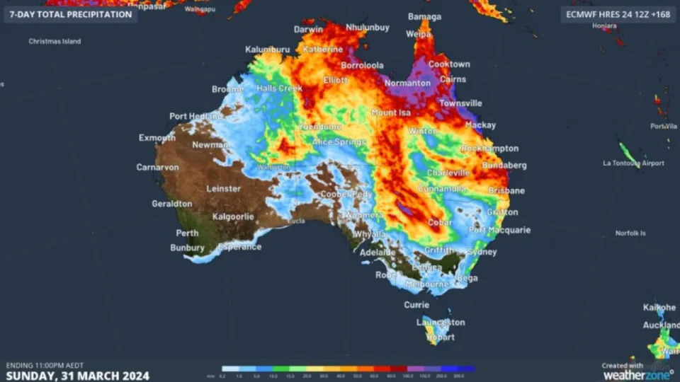
A wet and stormy Easter could be in store for some Aussies, with showers and thunderstorms expected to hit parts of the country throughout the long weekend.
The Bureau of Meteorology is anticipating a dry and mild start to the weekend for the majority of the country, with a few coastal showers forecast for Queensland and northeast NSW.
On Saturday, showers and thunderstorms will start to develop across northern South Australia and western NSW, with the Bureau warning there could be heavy rainfall.
For those in Australia’s southwest, Easter Sunday could be a chilly one, with a cold front expected to clip the region and bring some showers, before a cold front sweeps across the south east of the country bringing showers, thunderstorms and gusty winds on Monday.
NSW and ACT
Bureau of Meteorology senior meteorologist Dean Narramore said NSW and the ACT were looking at a “mostly fine” Easter weekend, with a few coastal showers along the east coast expected to hit on Friday.
Showers and thunderstorms will develop in western NSW throughout the weekend.
“Broadly speaking, NSW and the ACT overall are seeing a fine, warm and dry Easter long weekend,” Mr Narramore said.
Sydney can also expect “lots of sunshine” with temperatures to reach mid to high 20s.
Canberra will be dry and partly cloudy, with temperatures in the high 20s
Victoria
While Victorians can expect a warm and mostly sunny weekend, a cold front with showers, thunderstorms and gusty winds may hit the state on Monday.
Melbourne will experience mild to warm weather despite earlier forecasts indicating temperatures could soar to as high as 30 on Sunday.
Temperatures will sit in the mid to low 20s on Saturday but rise to high 20s for the rest of the weekend.
Tasmania
Tasmanians will be treated to mostly fine and dry conditions this long weekend but showers could develop throughout the state from Monday afternoon.
Temperatures in Hobart are expected to be in the low 20s before showers roll in on Monday.
South Australia
While dry conditions can be expected in the capital, Mr Narramore said those in northern parts of South Australia could see showers and thunderstorms develop throughout the weekend.
“Some of those could be heavy, but that’s unlikely to reach into southern parts of the state,” he said.
Forecasts predict a mostly dry and sunny weekend for Adelaide, with temperatures in the 30s for most days.
Western Australia
Mr Narramore said WA could expect a dry and warm to hot long weekend, with the only wet weather to be in the far eastern part of the state, near the NT and SA border.
The Kimberly region could experience showers and thunderstorms.
Temperatures are forecast to reach low to mid 30s in inland areas, while the Pilbara could experience temperatures in the high 30s.
Perth is set to experience temperatures near 30C each day.
Northern Territory
Widespread showers and thunderstorms are anticipated to hit much of the NT over the weekend.
Mr Narramore said the showers and thunderstorms were expected each day.
Queensland
Showers and thunderstorms already occurring in Queensland are expected to continue into the long weekend and early next week.
Widespread showers and thunderstorms will also continue for much of western and northern Queensland, while inland areas will remain dry.
In Brisbane, temperatures will likely sit in the high 20s.
Chance of rainfall
This means that, over the past few months when the forecast probability has been 30%, for example, rain above the relevant threshold has been recorded on 30% of occasions.
What is the highest rainfall in Australia in 24 hours?
Where is the rain in Australia?
Daily Forecast
Showers and rain over WA’s northeast, the NT, QLD’s north and east and northeast NSW, with abundant tropical moisture, along with storms in the north. Patchy light showers over eastern NSW, southern VIC and western TAS in onshore flow. A high keeps dry and settled elsewhere.
Why is Australia so wet this summer?
After three La Niña summers many of us would have been expecting much hotter and drier conditions this spring and summer after the arrival of El Niño. Instead, in many parts of eastern Australia it’s rained and rained over the last few weeks. El Niño hasn’t gone away. It’s expected to continue into 2024.
Why is Adelaide getting so much rain?
“It’s the direct result of climate change,” Professor Meyer says. “Ocean temperatures are warming and the climate projections show more intense summer rain and lower falls in winter and spring,” he says.
Why is Sydney so rainy?
In geography, the temperate climates of Earth occur in the middle latitudes (23.5° to 66.5° N/S of Equator), which span between the tropics and the polar regions of Earth.[1] These zones generally have wider temperature ranges throughout the year and more distinct seasonal changes compared to tropical climates, where such variations are often small and usually only have precipitation differences.[2]
In temperate climates, not only do latitudinal positions influence temperature changes, but various sea currents, prevailing wind direction, continentality (how large a landmass is) and altitude also shape temperate climates
The middle latitudes (also called the mid-latitudes, sometimes midlatitudes, or moderate latitudes) are a spatial region on Earth located between the Tropic of Cancer (latitudes 23°26’22”) to the Arctic Circle (66°33’39”), and Tropic of Capricorn (-23°26’22”) to the Antarctic Circle (-66°33’39”).[1][2] They include Earth’s subtropical and temperate zones, which lie between the two tropics and the polar circles. Weather fronts and extratropical cyclones are usually found in this area, as well as occasional tropical cyclones or subtropical cyclones, which have traveled from their areas of formation closer to the Equator.[3]
The prevailing winds in the middle latitudes are often very strong. These parts of the world also see a wide variety of fast-changing weather as cold air masses from the poles and warm air masses from the tropics constantly push up and down over them against each other, sometimes alternating within hours of each other, especially in the roaring forties (latitudes between 40° and 50° in both hemispheres)[citation needed], even though the winds on the northern hemisphere are not as strong as in the southern hemisphere, due to the large landmasses of North America, Europe and Asia.[4]
There are five types of mid-latitude climates: mediterranean, humid subtropical, marine west coast, humid continental and subarctic