
As officials assess the damage from destructive storms in the Houston area that killed at least seven people and knocked out power amid rising temperatures, residents in the Southeast and Gulf Coast face a severe weather threat through Saturday that could bring another round of excessive rainfall and severe thunderstorms.
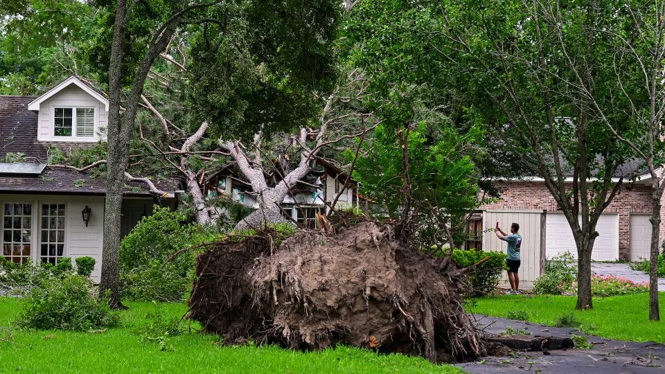
A complex of storms with winds up to 100 mph and a tornado left a trail of destruction Thursday across the Houston area that damaged multiple skyscrapers, caused a sewage spill and triggered power outages that could stretch on for weeks amid soaring temperatures.
At least four people died from the storm in Houston, including two killed by fallen trees and a third who died in a crane accident, Houston Fire Chief Samuel Peña said Thursday.

Another three storm deaths were reported in Harris County on Friday evening. One man collapsed while trying to move a downed electrical pole, and a woman died after lightning struck the trailer she was inside and sparked a fire, Harris County Sheriff Ed Gonzalez said in a post on X. Gonzalez said another victim who had lost power reportedly went out to his truck to plug in his oxygen tank and was found unresponsive Friday morning.
“Heartbreaking! My condolences go out to the families that lost a loved one during yesterday’s severe weather event,” Gonzalez said.
The damaging storms will be followed by high temperatures in the 90s through the weekend and beyond while many are without air conditioning.
Over 366,000 customers in Harris County remain without power Saturday evening following the line of storms, down from a peak of more than 900,000, according to PowerOutage.us. Authorities have warned that restoring power to all customers will be a lengthy process.
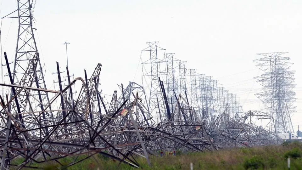
CenterPoint Energy – the primary electrical provider in the area – said the storm system caused “extensive damage to the company’s transmission and distribution electric systems.” Thousands of workers are being deployed to help with restoration efforts, the company said.
More than 376,000 of its customers have been affected and power was restored to more than 259,000 customers in the last 24 hours as of Saturday night, the company said on its website.
“CenterPoint Energy is working to have restorations substantially complete to customers who are available to receive service by end of day Wednesday,” CenterPoint Energy said. “Hardest hit areas of our territory include: Bellaire, Cypress, Baytown, Greenspoint, Humble and Spring Branch.”
The rainfall, combined with high winds and power outages, also resulted in the spillage of more than 100,000 gallons of domestic wastewater, otherwise known as sanitary sewage. The spillage occurred in three separate locations across the city, but Houston Public Works assured residents that drinking water from the City of Houston remains safe.
With burgeoning heat, the City of Houston opened cooling centers for residents on Friday, officials said in a news release. The heat index, which measures what the body actually feels, could hit triple-digits by next week, raising health risks from weather’s deadliest threat.
“The weather pattern is shifting into a hot and dry pattern starting on Saturday, so it is going to be important to have a way to stay cool,” the National Weather Service warned on Friday.
Houston Mayor John Whitmire, who signed a local state of disaster declaration for the city on Friday, toured the downtown area and said the “devastation is significant.”
“We urge everyone to stay away from the area for your safety and to allow public works personnel to do their vital jobs,” Whitmire said.
The weather service classified the line of severe storms that moved through Texas and Louisiana Thursday as a derecho, a potentially destructive weather event characterized by widespread wind damage associated with a long-lived line of thunderstorms.
Derechos have consistent wind gusts of 58 mph or greater along a path of at least 400 miles, along with several well-separated wind gusts of greater than 75 mph. The determination was made based on the path’s length and intensity.
More flash floods and damaging wind gusts possible Saturday
Excessive rainfall and severe thunderstorm chances will persist across parts of the Southeast through Saturday, the National Weather Service said.
From the Southeast to the north-central Gulf of Mexico, newly developing thunderstorms will bring the potential for more flash flooding and damaging wind gusts on Saturday, according to the National Weather Service.
A slight level 2 of 5 risk of severe thunderstorms has been issued across parts of the Southeast into the Carolinas on Saturday, according to the Storm Prediction Center.
“Isolated to scattered severe thunderstorms appear possible across portions of the Southeast and Carolinas on Saturday, and parts of the Upper Midwest,” the center said. “Damaging winds should be the main threat, but occasional severe hail and a tornado or two may also occur.”
A slight level 2 of 4 risk of excessive rainfall has also been issued for part of the northern Gulf Coast Saturday due to the threat of flash, urban and riverine flooding, the weather service said.
Heavy rain is also forecast to continue into Saturday across the Mid-Atlantic and central Appalachians, where scattered instances of flash flooding could occur.
On Sunday, thunderstorms are expected to form over the central High Plains and spread east in the evening. The greatest chances for severe weather are across parts of Nebraska and Kansas, with a slight level 2 of 5 risk of severe thunderstorms issued by the Storm Prediction Center.
“Large hail and damaging gusts will be the main hazards, though a tornado or two also will be possible,” the center said.
By the end of the weekend, thunderstorm chances will diminish for most of the Southeast and Mid-Atlantic, the weather service said.
Gonzales said another victim who had lost power reportedly went out to his truck to plug in his oxygen tank. “He was found unresponsive this morning and pronounced deceased at the scene,” the sheriff said Friday, adding the additional deaths occurred in unincorporated Harris County.
Houston Mayor John Whitmire, who signed a local state of disaster declaration for the city on Friday, toured the downtown area and said the “devastation is significant.”
“We urge everyone to stay away from the area for your safety and to allow public works personnel to do their vital jobs,” Whitmire said.
Additional powerful, drenching storms could plague parts of the Gulf Coast Friday.
Here’s the latest on Friday’s storms and destruction in Texas and other parts of the South:
Thursday’s severe weather classified as derecho: The weather service classified the line of severe storms that moved through Texas and Louisiana as a derecho, a potentially destructive weather event characterized by widespread wind damage associated with a long-lived line of thunderstorms. Derechos have consistent wind gusts of 58 mph or greater along a path of at least 400 miles, along with several well-separated wind gusts of greater than 75 mph. The Storm Prediction Center and several National Weather Service offices made the determination based on the path’s length and intensity.
Most of Houston’s traffic lights are down: Traffic lights across the city are out and debris from damaged buildings and toppled trees are covering roadways, making driving conditions dangerous. “Downtown is a mess. It’s dangerous due to the glass and the lack of traffic lights. So stay at home,” Mayor Whitmire said Thursday.
Hurricane-force wind gusts reported in Texas and Louisiana: Wind speeds reached as high as 100 mph in downtown Houston, a National Weather Service storm damage survey crew determined Friday. Wind gusts of 74 to 78 mph were measured just east of the Houston metro Thursday evening, according to the weather service. The National Weather Service in New Orleans reported wind gusts as strong as 84 mph around the city.
Major flooding leads to water rescues: There were up to 20 water rescues after residents in Bryan, Texas, drove into the floodwaters, police spokesperson Seth Waller said. Nearby in College Station, heavy rain Thursday flooded a park, videos shared with CNN showed. Roads flooded in several Texas counties including Bosque, Bell, McLennan and Falls. Waterlogged parts of Texas and Louisiana recorded widespread rainfall amounts of 2 to 4 inches in just a few hours late Thursday and early Friday morning.