Wind shear refers to the change in wind speed and direction between roughly 5,000-35,000 feet above the ground, NOAA said. Strong vertical wind shear can rip a developing hurricane apart, or even prevent it from forming. This is what can happen in the Atlantic during an El Niño when Atlantic hurricane activity is often suppressed.
What does La Niña mean for weather in the US? La Niña and El Niño typically have minimal impact on U.S. weather in the summer, other than their effect on hurricanes. Winter is the one season in which they have the most impact.
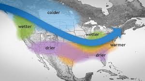
A typical La Niña winter in the U.S. brings cold and snow to the Northwest and unusually dry conditions to most of the nation’s southern tier, according to the Climate Prediction Center. The Southeast and mid-Atlantic also tend to see warmer-than-average temperatures during a La Niña winter.
Meanwhile, New England and the Upper Midwest into New York tend to see colder-than-average temperatures, the Weather Channel said.
The National Hurricane Center issued its first advisory of the year on Wednesday , a month before the official start of the Atlantic hurricane season .
The advisory was issued for a tropical disturbance that was far out to sea, and has since dissipated, the hurricane center said late Wednesday.
The otherwise nondescript system was notable for being the first sign of what’s expected to be a ferocious hurricane season in the Atlantic , with potentially dozens of storms.
Preseason forecasts from top hurricane experts point to a “hyperactive” or “explosive” season. One group Wednesday from the University of Pennsylvania predicted a record-breaking 33 named storms this year.
Where was the disturbance? The disturbance was located in the Atlantic Ocean, about 900 miles northwest of the Cabo Verde Islands on Wednesday, the hurricane center said . It had produced “a small but persistent area of showers and thunderstorms to the east of its center since Wednesday morning.”
The hurricane center gave it a “low” chance for development into a tropical cyclone, and that came to fruition late Wednesday as the system dissipated: “Additional development is not expected,” the hurricane center said.
The hurricane center will issue daily tropical outlooks beginning May 15, unless a disturbance worth monitoring appears earlier in the Atlantic basin. The Atlantic basin covers the northern Atlantic, the Caribbean Sea and the Gulf of Mexico.
When does the hurricane season start? The 2024 Atlantic hurricane season officially starts June 1. However, “preseason” storms have formed with regularity in May over the past decade. One — Tropical Storm Arlene in 2017 — formed in April.
This year, the first hurricane name will be Alberto.
Is El Niño or La Niña worse?
During La Niña conditions, the jet streams are much more variable and amplified. Generally this means drier and warmer conditions across the southwestern United States. But because the jet stream is amplified, there can be much more frequent cold air outbreaks than what is seen during El Niño. Will there be a hurricane in Florida in 2024?
The Outlook What are the effects of La Niña?
La Niña causes the jet stream to move northward and to weaken over the eastern Pacific. During La Niña winters, the South sees warmer and drier conditions than usual. The North and Canada tend to be wetter and colder. During La Niña, waters off the Pacific coast are colder and contain more nutrients than usual. La Niña is characterized by unusually cold ocean temperatures in the Equatorial Pacific, compared to El Niño, which is characterized by unusually warm ocean temperatures in the Equatorial Pacific.
Why do hurricanes hit Florida every year? With its long coastline and location, Florida frequently finds itself in the path of these intense storms. The southeast coastline is extremely susceptible to a land-falling hurricane, followed by the panhandle.
How long can a hurricane last in Florida? The eye of a storm is usually 20-30 miles wide and may extend more than 400 miles. The dangers of a storm include torrential rains, high winds, and storm surges. A hurricane can last for two weeks or more over open water and can run a path across the entire length of the eastern seaboard.
How many years has Florida not had a hurricane? More storms hit Florida than any other U.S. state, and since 1851 only eighteen hurricane seasons passed without a known storm impacting the state. Collectively, cyclones that hit the region have resulted in over 10,000 deaths, most of which occurred prior to the start of hurricane hunter flights in 1943.
Why is La Niña called Little Girl? La Nina means The Little Girl in Spanish. It is also sometimes called El Viejo, anti-El Nino, or simply “a cold event.” La Nina events represent periods of below-average sea surface temperatures across the east-central Equatorial Pacific. Why is La Niña called Little Girl?
La Nina means The Little Girl in Spanish. It is also sometimes called El Viejo, anti-El Nino, or simply “a cold event.” La Nina events represent periods of below-average sea surface temperatures across the east-central Equatorial Pacific.
Will we have La Niña in 2024? La Niña tends to follow strong El Niño events, which also provides added confidence in the model guidance favoring La Niña. In summary, a transition from El Niño to ENSO-neutral is likely by April-June 2024 (85% chance), with the odds of La Niña developing by June-August 2024 La Niña is a phenomenon that describes cooler than normal ocean surface temperatures in the Eastern and Central Pacific Ocean, regions close to the equator off the west coast of South America. In some parts of the world, La Niña causes increased rainfall, while in other regions, it causes extreme dry conditions.
How long do tornadoes last? Nevertheless, ground time can range from an instant to several hours, although the typical time is around 5 to perhaps 10 minutes. Supercell tornadoes tend to be longer-lived, while those pawned by squall lines and bow echoes may only last for a few minutes.
What was the worst hurricane in history? The 1900 Galveston hurricane, also known as the Great Galveston hurricane and the Galveston Flood, and known regionally as the Great Storm of 1900 or the 1900 Storm, is the deadliest natural disaster in United States history.
Why is El Niño called Little Boy? This development is a temporary replacement of the cold current along the coast of Peru. El Nino is a Spanish word. The term El Nino basically means ‘the child’. This is due to the fact that this current starts to flow around Christmas and hence the name referring to baby Christ.
What is the opposite of La Niña? El Niño and La Niña are opposite phases of a natural climate pattern across the tropical Pacific Ocean that swings back and forth every 3-7 years on average. Together, they are called ENSO (pronounced “en-so”), which is short for El Niño-Southern Oscillation.