April begins Monday, and Mother Nature is bringing everything but the kitchen sink. A multi-day system will slide across much of the country and bring the potential for tornadoes, large hail, flooding and even snow. As if that weren’t enough, there could also be record warm temperatures.
Widespread precipitation is expected as the very large system traverses from the Central US on Sunday to the Northeast by midweek. Snow and freezing rain will fall to the north, while heavy rain and severe thunderstorms unfold on the warmer side of the system.
April is traditionally when severe thunderstorm activity begins to ramp up. More than half of the tornadoes in an average year occur from April through June, according to the Storm Prediction Center.

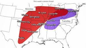
The weather this April is following suit. On Monday, severe thunderstorms are possible from northern Texas to southern Ohio. The main threats are tornadoes, damaging winds and golf ball-sized hail or larger. The best chance for severe storms will occur in the afternoon and continue through the evening hours. Nighttime tornadoes are more deadly, so make sure you have a way to get warnings if you live in these areas.
By Tuesday, the severe threat shifts east into an area from northern Mississippi to southern Pennsylvania. While tornadoes cannot be ruled out, the greatest threat here will be damaging winds.
The threat for flooding will be highest from Missouri through Pennsylvania beginning on Monday. As the storm progresses east, these areas could see rainfall totals of up to 3 inches through midweek.
One of the elements fueling the severe threat is the clash of cold air behind the system with the warm air out ahead. For some Southern cities, the warmth could break records.
Baton Rouge, Louisiana, along with Corpus Christi and Del Rio, Texas, could see record high temperatures on Monday. Laredo, Texas, could also break a daily record high on Monday if the city reaches its forecast of 101 degrees – its normal high temperature for July 24.
But while some parts of the South may feel more like summer, parts of the northern tier of the US will look and feel more like winter next week.
Snow as well as freezing rain could be the big threats from the Upper Midwest into the Great Lakes on Monday.

Rapid City, South Dakota, is forecast to pick up 3 to 6 inches of snow Sunday and Monday with high temperatures only in the mid-30s – the normal high for early February.
Minneapolis will see a mix of rain and snow, but even just an inch or two of snow will bring the city’s spring snowfall total to more than 16 inches – more snow than they picked up all winter.
By Tuesday, the snow and ice shifts to interior areas of the Northeast and in the higher elevations of the Green, White and Adirondack Mountains. Snow may linger well into Thursday. These areas could end up seeing more snow than the Midwest simply because of the longer duration of the snow event.
Snow amounts are subject to considerable change with the forecast still 3 to 5 days out, so keep checking back over the next few days for the latest thinking.
It looks like Mother Nature has her seasons mixed up as a potent, far-reaching storm gears up to unload snow, ice and severe thunderstorms on the central US this weekend.
In a seasonal role-reversal, back-to-back storms are sending some cities as much snow as they had all winter.
The first storm dropped several inches of snow from the northern Plains to the Great Lakes, beginning Thursday night and continuing into Friday morning. Snowfall totals ranged from 2 to 5 inches over the Minneapolis-St. Paul metro area during that time.
Snow will persist through Friday evening over the Great Lakes before the quick-moving storm slides into the Northeast on Saturday.
The second storm will arrive in the central US on Sunday. This encore is expected to outperform its predecessor, ushering in widespread, troublesome and longer-lasting impacts.
“Disruptions to daily life” are likely as a result of this storm, the Weather Prediction Center warned on Friday.
Snow is likely to spread from the northern Rockies to the Midwest on Sunday as the storm moves from the Rockies into the Plains and strengthens. Winds will become quite gusty as the storm grows. Blowing snow could create very poor visibility, affecting travel on the ground and in the air.
Widespread snowfall totals of over half a foot are likely in multiple north-central states. Over a foot of snow is possible where the heaviest snow centers. This far in advance, it’s difficult to say exactly where these highest totals will occur, but the Dakotas and Minnesota could end up in the bull’s-eye.
Snow will continue to bury the northern US as the storm pushes east on Monday.
Minneapolis received less than a foot of snow from December through February – 2 feet short of what a typical winter brings. But what it got over the course of three months may be matched – or exceeded – in a matter of days. A similar scenario could play out in Fargo, North Dakota, and Aberdeen, South Dakota.
Damaging thunderstorms will rumble to life
Unlike the first quick-hitting storm, the storm arriving early next week will create hazards beyond snow. Cold air trailing behind the wide-reaching storm’s cold front will clash with warm, moist air in place over the South and produce severe thunderstorms Sunday and Monday.
The risk on Sunday will affect areas from Texas through Kansas. Damaging thunderstorms are expected to fire up late Sunday afternoon from central Texas to central Kansas and track slowly eastward through the evening.

Wind gusts in excess of 60 mph, hail bigger than quarters and a few tornadoes are possible.
The bull’s-eye of severe thunderstorm risk will shift east on Monday and capture parts of the Lower Mississippi Valley and Southeast.
Hazardous thunderstorm activity could get underway by Monday afternoon from Texas to Arkansas and expand in scope as storms track east through the evening hours.
Severe hazards are once again possible Monday.
Thunderstorms will rumble across the South on Tuesday, but the threat for widespread damaging storms appears to be limited.
A normal winter was hard to come by, according to an index from the Midwest Regional Climate Center which tracks the aggregate toll of cold and snow at hundreds of locations across the country.
Winter warmth started off at a blistering pace. December was the warmest on record for the Lower 48, a full 7.3 degrees Fahrenheit above average. Aside from one brutal cold spell in January, it continued through the season, with February finishing as the third-warmest on record.
Unusual February heat wasn’t limited to the US. February was the Earth’s hottest on record, marking the ninth month in a row global records tumbled, according to Copernicus, the European Union’s climate monitoring service.
In the US, a classic El Niño pattern had a strong hand in amplifying temperatures, particularly in the Midwest and Northeast where winter felt more like spring.
Eight states experienced a record-warm winter: North Dakota, Minnesota, Iowa, Wisconsin, Michigan, New York, Vermont and New Hampshire.
Temperatures were several degrees above normal in dozens of cities from the north-central US to the Northeast – another clear indicator of exceptional warmth.
Areas downwind of the Great Lakes had some of the greatest snowfall deficits due to a lack of lake-effect snow. Without these robust snow events to bulk up totals, Erie, Pennsylvania, missed out on just over five feet of typical winter snow.
The lack of snow and ice is having a serious impact on small businesses that rely on it to operate, prompting the governors of Michigan and Minnesota to encourage business owners to seek federal assistance through the Small Business Administration.
“From skiing and snowshoeing to winter festivals, snowy winters are part of our way of life in Minnesota,” Minnesota Gov. Tim Waltz said in a news release. “The low precipitation we’ve experienced this winter has had a real economic impact on small businesses that rely on snow and winter tourism to grow and survive.”
Significant snowfall deficits and the unusual warmth are also worsening drought conditions in parts of the Midwest. Severe drought expanded over portions of Wisconsin and Michigan and extreme drought increased in Iowa, according to the latest US Drought Monitor.
The lack of cold air also shattered chances for prolonged, expansive ice coverage across the Great Lakes.
Ice coverage across all five lakes averaged just 5.6% from Jan 1 to March 7, the lowest level since 1973, said James Kessler, a physical scientist at NOAA’s Great Lakes Environmental Research Lab.
“That’s fairly remarkable to say,” Kessler told CNN.