‘Extremely active’ season predicted
“Everything is leaning toward an extremely active season: still record warm Atlantic water temperatures and a pretty rapid transition over to La Niña,” he said.
A typical year averages about 14 tropical storms, and seven spinning into hurricanes, based on weather records that date from 1991 to 2020.
Others also predict an active season
Also predicting an active Atlantic season are the UK Met Office and the European Center for Medium-Range Weather Forecasts, which calls for nine hurricanes between April and September, he said. Most storm activity typically happens between mid-August and mid-October.
“If Bill Gray knew we were forecasting this, he’d think we’d gone nuts,” Klotzbach told USA TODAY last week, referring to his late mentor, who pioneered seasonal hurricane outlooks for the Atlantic.
Buckle up and hunker down: An “extremely active” hurricane season is likely, top forecasters from Colorado State University announced Thursday. In fact, the forecast includes the highest number of hurricanes ever predicted in an April forecast by Colorado State since the team began issuing predictions in 1995.
Colorado State hurricane forecaster Phil Klotzbach, the author of the forecast, knows what the models show him about the hurricane season that starts June 1, but he’s a bit incredulous it could really be that busy.
“We’re coming out with a very aggressive forecast: 23 named storms, 11 hurricanes and five major hurricanes,” said Klotzbach, a senior research scientist in the atmospheric science department at Colorado State University. “And even that is so undercutting all the model guidance.”The seasonal outlook from the National Oceanic and Atmospheric Administration isn’t due out until May, but those forecasters are looking at the same worrisome models and temperatures that Klotzbach is seeing.
“Nothing surprises me anymore,” said Robbie Berg, a hurricane specialist at the National Hurricane Center.
Last year, when many forecasts called for a milder season, there were 20 named storms, Berg told USA TODAY. That’s six more than normal and the fourth-most named storms on record.”Our message last year was like ‘don’t focus on this because we know that there’s other factors that come into play in how many storms we get and how strong they get,” Berg said. “These signals are that we’re heading toward a La Niña, that would tend to support more storms,” he said, and the water is “very warm.”Warm water gives hurricanes fuel and contributes to a more unstable atmosphere. La Niña − one phase of a cyclical pattern in water temperatures and winds along the equator in the Pacific Ocean − can affect weather patterns worldwide.
What about landfalls?
The seasonal forecast models have little to do with where hurricanes make landfall. Tropical storms and hurricanes are steered around in part by where high-pressure ridges set up over the ocean
However, La Nina tends to allow more hurricanes to move more westward across the Atlantic rather than peeling off to the north as they approach the islands in the far eastern Caribbean, Klotzbach said. That favors hurricane landfalls along the East Coast from Florida to Maine, he said, and more toward Florida than Texas and Alabama.
Klotzbach expects to see La Niña conditions appear over the next couple of months. In a typical climate pattern, La Niña leads to more activity in the Atlantic region because the lighter winds in the upper atmosphere allow hurricanes to build up the big powerful cloud tops that give them their oomph, while El Niño drops in winds over the Atlantic that work against those high cloud tops.
How do hurricanes form? An inside look at the birth and power of ferocious storms
But lately, things over the Atlantic Ocean have been anything but typical. Despite the El Niño last year, the Atlantic produced seven hurricanes, the average for a typical season.
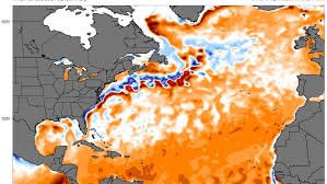
Record warmth in the Atlantic Ocean
Ocean temperatures in much of the Atlantic have been setting records for more than a year, and scientists have been unable to fully explain why.
“Obviously there’s still a lot that can change,” Klotzbach said, but not that much. Even if the Atlantic warms the least between February and September that it’s warmed over the same period any time in the last 40 years, “we’d be at the second-warmest on record going back to 1980.”
“It’s going to be hard to get the Atlantic cool at this point,” he said, “unless we have a tropical volcano eruption or something like that.”This season could be active, “but that doesn’t tell us anything about where those storms may move,” Berg said. “So maybe we’d get lucky and have them stay out over the Atlantic. But we don’t know that and that’s why every year we still have to be prepared because whether it’s 10 storms or 20 storms, where they form, where they move is what’s critically important.”
Forecast for 2024 Hurricane Activity
Forecast Parameters | CSU Forecast for 2024* | Average for 1991-2020 |
---|---|---|
Named Storms | 23 | 14.4 |
Named Storm Days | 115 | 69.4 |
Hurricanes | 11 | 7.2 |
Hurricane Days | 45 | 27.0 |
Major Hurricanes | 5 | 3.2 |
Major Hurricane Days | 13 | 7.4 |
Accumulated Cyclone Energy (ACE)+ | 210 | 123 |
ACE West of 60 degrees longitude | 125 | 73 |
*CSU released its first seasonal forecast for 2024 on Thursday, April 4. | ||
+A measure of a named storm’s potential for wind and storm surge destruction defined as the sum of the square of a named storm’s maximum wind speed (in 104 knots2) for each 6-hour period of its existence. |
EXTENDED RANGE FORECAST OF ATLANTIC SEASONAL HURRICANE
ACTIVITY AND LANDFALL STRIKE PROBABILITY FOR 2024
We anticipate that the 2024 Atlantic basin hurricane season will be extremely active.
Current El Niño conditions are likely to transition to La Niña conditions this summer/fall,
leading to hurricane-favorable wind shear conditions. Sea surface temperatures in the
eastern and central Atlantic are currently at record warm levels and are anticipated to
remain well above average for the upcoming hurricane season. A warmer-than-normal
tropical Atlantic provides a more conducive dynamic and thermodynamic environment
for hurricane formation and intensification. This forecast is of above-normal confidence
for an early April outlook. We anticipate a well above-average probability for major
hurricanes making landfall along the continental United States coastline and in the
Caribbean. As with all hurricane seasons, coastal residents are reminded that it only takes
one hurricane making landfall to make it an active season. Thorough preparations should
be made every season, regardless of predicted activity.
(as of 4 April 2024)
By Philip J. Klotzbach1
, Michael M. Bell2
, Alexander J. DesRosiers3
, and Levi
Silvers4
With Special Assistance from Carl J. Schreck III5
In Memory of William M. Gray6
Jennifer Dimas, Colorado State University media representative, is coordinating media
inquiries in English and Spanish. She can be reached at 970-491-1543 or
Jennifer.Dimas@colostate.edu
Department of Atmospheric Science, Colorado State University, Fort Collins CO 80523
By CSU MarComm. Staff
Note to reporters: The full forecast is available at tropical.colostate.edu. CSU will be releasing
the forecast live at 10 a.m. EDT on April 4 from the National Tropical Weather Conference. There
will be a live stream of the event. The CSU team will also issue forecast updates on June 11, July
9 and Aug. 6. Please contact Jennifer Dimas (Jennifer.Dimas@colostate.edu) for English and
Spanish media inquiries and if you would like to be included in future news release sends.
Colorado State University hurricane researchers are predicting an extremely active Atlantic
hurricane season in their initial 2024 forecast. The team cites record warm tropical and eastern
subtropical Atlantic sea surface temperatures as a primary factor for their prediction of 11
hurricanes this year.
When waters in the eastern and central tropical and subtropical Atlantic are much warmer than
normal in the spring, it tends to force a weaker subtropical high and associated weaker winds
blowing across the tropical Atlantic. These conditions will likely lead to a continuation of well
above-average water temperatures in the tropical Atlantic for the peak of the 2024 Atlantic
hurricane season. A very warm Atlantic favors an above-average season, since a hurricane’s fuel
source is warm ocean water. In addition, a warm Atlantic leads to lower atmospheric pressure
and a more unstable atmosphere. Both conditions favor hurricanes.
While the tropical Pacific is currently characterized by El Niño conditions, these are likely to
transition to La Niña conditions by the peak of the Atlantic hurricane season from August to
October. La Niña tends to decrease upper-level westerly winds across the Caribbean into the
tropical Atlantic. These decreased upper-level winds result in reduced vertical wind shear,
favoring Atlantic hurricane formation and intensification.
Given the combined hurricane-favorable signals of an extremely warm Atlantic and a likely
developing La Niña, the forecast team has higher-than-normal confidence for an April outlook
that the 2024 Atlantic hurricane season will be very active. This is the highest prediction for
hurricanes that CSU has ever issued with their April outlook. The prior highest April forecast
was for nine hurricanes, which has been called for several times since the university began
issuing April forecasts in 1995. However, the team stresses that the April outlook historically
has the lowest level of skill of CSU’s operational seasonal hurricane forecasts, given the
considerable changes that can occur in the atmosphere-ocean between April and the peak of
the Atlantic hurricane season from August–October.
CSU Tropical Weather and Climate team predicts 23 named storms in 2024
The CSU Tropical Weather and Climate team is predicting 23 named storms during the Atlantic
hurricane season, which runs from June 1 to Nov. 30. Of those, researchers forecast eleven to
become hurricanes and five to reach major hurricane strength (Saffir/Simpson Category 3-4-5)
with sustained winds of 111 miles per hour or greater.
The team bases its forecasts on a statistical model, as well as four models that use a
combination of statistical information and model predictions of large-scale conditions from the
European Centre for Medium-Range Weather Forecasts, the UK Met Office, the Japan
Meteorological Agency, and the Centro Euro-Mediterraneo sui Cambiamenti Climatici. These
models use 25-40 years of historical hurricane seasons and evaluate conditions including:
Atlantic sea surface temperatures, sea level pressures, vertical wind shear levels (the change in
wind direction and speed with height in the atmosphere), El Niño (warming of waters in the
central and eastern tropical Pacific), and other factors.
So far, the 2024 hurricane season is exhibiting characteristics similar to 1878, 1926, 1998, 2010
and 2020.
“Our analog seasons were all very active Atlantic hurricane seasons,” said Phil Klotzbach, senior
research scientist in the Department of Atmospheric Science at CSU and lead author of the
report. “This highlights the somewhat lower levels of uncertainty that exist with this outlook
relative to our typical early April outlook.”
The team predicts that 2024 hurricane activity will be about 170% of the average season from
1991–2020. By comparison, 2023’s hurricane activity was about 120% of the average season.
The most significant hurricane of the 2023 Atlantic hurricane season was Hurricane Idalia. Idalia
made landfall at Category 3 intensity in the Big Bend region of Florida, causing $3.6 billion
dollars in damage and resulting in eight direct fatalities.
In addition to the various hurricane metrics that CSU has used for many years, the forecast
team introduced a new metric last year. Accumulated Cyclone Energy (ACE) occurring west of
60 degrees west longitude is an integrated metric accounting for storm frequency, intensity and
duration in the western half of the Atlantic basin. ACE generated west of 60 degrees west
correlates better with landfalling storms in the Atlantic basin than basinwide ACE, since virtually
all hurricane-prone landmasses in the Atlantic Ocean are located west of 60 degrees west.
Generally, a slightly lower percentage of basinwide ACE occurs west of 60 degrees west in El
Niño years relative to La Niña years. Since the team anticipates La Niña as the most likely
outcome in 2024, the percentage of basinwide ACE occurring west of 60 degrees west is
predicted to be higher than last year.
The CSU team will issue forecast updates on June 11, July 9 and Aug. 6.
This is the 41st year that CSU has issued an Atlantic basin seasonal hurricane forecast. Professor
Emeritus Bill Gray originated the seasonal forecasts at CSU and launched the report in 1984. He
continued to author them until his death in 2016. The authors of this year’s forecast are Phil
Klotzbach, Professor Michael Bell, Ph.D. candidate Alex DesRosiers, and Research Scientist Levi
Silvers. The CSU Tropical Weather and Climate Team is part of the Department of Atmospheric
Science in the Walter Scott, Jr. College of Engineering at CSU and is one of the top ranked
Atmospheric Science programs in the world.
The CSU forecast is intended to provide a best estimate of activity in the Atlantic during the
upcoming season – not an exact measure.
As always, the researchers caution coastal residents to take proper precautions.
“It takes only one storm near you to make this an active season for you,” Bell said.
Hurricane landfalling probability included in 2024 report
The report also includes the probability of major hurricanes making landfall:
• 62% for the entire U.S. coastline (average from 1880–2020 is 43%).
• 34% for the U.S. East Coast, including the Florida peninsula (average from 1880–2020 is
21%).
• 42% for the Gulf Coast from the Florida panhandle westward to Brownsville (average
from 1880–2020 is 27%).
• 66% for the Caribbean (average from 1880–2020 is 47%).
The forecast team also provides probabilities of named storms, hurricanes and major
hurricanes tracking within 50 miles of each county or parish along the Gulf and U.S. East Coast,
as well as hurricane-prone coastal states, Mexican states, Canadian provinces and countries in
Central America and the Caribbean. These probabilities for regions and countries are adjusted
based on the current seasonal forecast.
Funding for this year’s report has been provided by Ironshore Insurance, the Insurance
Information Institute, Weatherboy, Insurance Auto Auctions and a grant from the G.
Unger Vetlesen Foundation.
ATLANTIC BASIN SEASONAL HURRICANE FORECAST FOR 2024
Forecast Parameter and 1991–2020
Average (in parentheses)
Issue Date
4 April 2024
Named Storms (NS) (14.4) 23
Named Storm Days (NSD) (69.4) 115
Hurricanes (H) (7.2) 11
Hurricane Days (HD) (27.0) 45
Major Hurricanes (MH) (3.2) 5
Major Hurricane Days (MHD) (7.4) 13
Accumulated Cyclone Energy (ACE) (123)
ACE West of 60°W (73)
210
125
Net Tropical Cyclone Activity (NTC) (135%) 220